Many of the common plant species we see around us are actually considered “invasive species.” They are labelled as such when they cause ecological disruption to geographic areas by crowding out native vegetation—sometimes to the point of extinction—or when they have the potential to interfere with public land use. To establish effective strategies for monitoring and controlling the spread of invasive species, public bodies may use geographic survey maps showing vegetation coverage. RPAS offer the potential to survey large land areas more efficiently and cost-effectively than ground-based work, but they can only offer an advantage if they produce survey maps of comparable quality.
Dr. Eric Saczuk first teamed up with Forest and Natural Areas Management (FNAM) students a few years ago to compare the quality of multispectral image-mapping with traditional field-mapping of invasive species. The goal was to compare the performance of two aerial cameras in their ability to detect Himalayan blackberry and canary reed grass, and to assess the overall accuracy of both cameras.
The group conducted several flights at Boundary Bay Regional Park with a DJI Inspire 2 drone, alternating MicaSense RedEdge M and Parrot Sequoia multispectral cameras mounted as payload. They processed the data into orthophoto maps to compare with results FNAM students had gathered previously using fieldwork and satellite imagery.
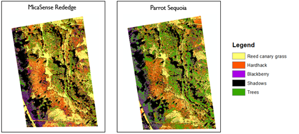
Overall, the agreement between the RPAS test maps and the classified maps was stronger for the Parrot Sequoia, but still low overall. However, the project produced data sets now used for training in various BCIT classes and raised hypotheses about how to generate more detailed, useful maps of invasive species in the future using RPAS technology.
A more recent student project sponsored by Dr. Saczuk, this time for Geographic Information Systems, also investigated the accuracy of classification maps created with multispectral images for use in invasive species management*. This time, a student duo documented the populations of Himalayan blackberry, English ivy, various laurel varieties, and English holly on the Burnaby BCIT campus, again comparing drone-collected data with field data. The goal was to test the accuracy of different algorithms and classification systems in processing the data to create maps that give a true picture of plant populations. The students’ analysis determined a clear advantage to certain methods and, as with the earlier research project, led to suggestions on how to make data-gathering via drones more concise in future efforts.
These projects supported by the RPAS Hub give students a valuable opportunity to apply new technologies and high-level research skills to work being performed by different organizations in the broader community.
*Using Multi-Spectral Data to Create a Classified Map of the Invasive Species on the South Campus of BCIT, by Sayumi Standen and Debbie Wong, GIST8125 Final Report, May 19, 2023.