Overview
The Geomatics Engineering Technology diploma program is a two-year course of study leading to a nationally recognized and accredited Diploma in Geomatics Technology. Students in this program acquire a solid background in applied math and physics, cartography, photogrammetry, field surveying, geodetic surveying, and computer applications.
BCIT Geomatics Diploma: Launch Your High-Tech Spatial Career
Ready to command cutting-edge technology and shape the world around you from right here in the vibrant tech landscape of British Columbia? The BCIT Geomatics Engineering Technology Diploma program is your accelerated path to becoming a highly sought-after spatial data specialist in just two years. Dive into the thrilling realm where the digital and physical worlds collide, mastering the skills that power smart cities, environmental intelligence, essential civil engineering and construction projects, the intricate precision of modern land surveying, and the future of mapping.
Our nationally recognized and TAC Canada accredited diploma ignites your passion with a powerful blend of theoretical know-how and immersive hands-on expertise. You’ll master essential principles in:
- Applied Mathematics & Physics: The analytical foundation for complex geospatial challenges.
- Precision CAD & Digital Design: Command industry-leading software like MicroSurvey and Civil3D to craft stunning 3D drawings and technical drawings that bring visions to life.
- Remote Sensing & Introduction to Drone Mapping: Explore aerial imagery and foundational drone technology, interpreting laser scan data to build intricate digital models of our planet.
- Field Surveying: Develop expertise in precise land measurements and boundary determination, essential for construction layout and infrastructure development, venturing into diverse environments with state-of-the-art equipment.
- Geodetic Positioning & Global Frameworks: Master the science of Earth’s precise measurement and its coordinate systems, enabling seamless, accurate positioning for projects ranging from local construction sites to continent-spanning infrastructure and international data sharing.
- Hydrography: Learn techniques for mapping underwater terrain and water bodies for marine and coastal applications.
- Digital Twin Creation & Spatial Intelligence: Leverage powerful software for advanced data analysis, modeling (including digital twin creation), and presentation of laser scanning data and other geospatial information.
Applied Learning: Real-World Skills, Immediate Impact
At BCIT, move beyond theory to real-world application. Our Geomatics diploma provides
intensive, hands-on training with the same industry-standard tools used by top
professionals. You’ll develop proficiency in:
- Next-Gen Surveying: Command GNSS (GPS) with pinpoint accuracy, utilize robotic total stations, and employ laser scanners for rapid data capture.
- Data Analysis & Visualization: Transform raw data – including detailed laser scan point clouds – into actionable insights, creating captivating digital maps and dynamic 3D models.
- Cutting-Edge Application: Work directly with drone technology, analyze stunning aerial photography, and manipulate intricate laser scan data to develop comprehensive digital twins and impactful 3D representations of any environment.
Ready to Engineer Your Spatial Future?
This program is ideal for analytical minds passionate about mathematics, the power of computers, and the science of our planet. If you’re driven by the blend of dynamic outdoor fieldwork and precise in-office technical analysis of data from advanced tools like laser scanners, robotic total stations, and drones, and you’re eager to shape our infrastructure, protect our environment, and build smarter communities across Canada and beyond, the BCIT Geomatics Diploma is your pathway to success.
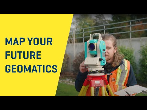
Survey a career
The YouTube video was produced at BCIT’s Burnaby Campus and offers an insight into the exciting career of a land surveyor. For further information on becoming a BC Land Surveyor visit www.abcls.ca.
Entrance Requirements
Scheduled intakes
September each year.
Application processing
Applications are accepted during the following periods:
| Opening (9:00 am) | Deadline (11:59 pm) |
|---|---|
| October 1st* | Domestic students: September 1st* International students: July 2nd* |
*or next business day
Intake may fill before the deadline.
Entrance requirements
Applicants must meet all entrance requirements and will be accepted on a first-qualified basis as long as space remains.
- English language proficiency: Category 2 – English Studies 12 (67%) or equivalent
- Math: one of the following:
- Pre-Calculus 12 (60%) or
- Other acceptable BC and Yukon courses
- Physics 11 (50%)
International applicants
This program is available to international applicants.
Study permit: A valid BCIT study permit is required prior to starting the program.
Post-graduation Work Permit (PGWP) eligibility: This program does not meet the eligible field of study requirement (CIP) and is therefore not eligible for students to apply for a PGWP.
(CIPC: 45.0702)
Apply to program
To submit your application:
- Include proof of meeting all entrance requirements.
- Convert all transcripts and supporting documents to PDF files.
- Have a credit card ready to pay the application fee.
Apply Now
Technology entry
The Technology Entry (TE) program is a full-time, day school program which provides academic upgrading to students wishing to enroll in Computing, Engineering, Electronic, and Health Sciences programs at BCIT.
The TE program provides courses in chemistry, communication, mathematics, and physics that meet program prerequisites for selected programs at BCIT. The TE program also includes an introductory course in computer applications and a learning skills course. The program is supportive to those who require English-language training.
myCommunication
Within two business days of submitting your completed application, BCIT will send a message to your personal and myBCIT email addresses. All correspondence regarding your application will be posted to your online myCommunication account at my.bcit.ca. We will send you an email when a new message is posted. It is important to watch for these emails or regularly check your account online.
You can expect to receive communication concerning the status of your application within four weeks.
Advanced Placement
Conditions
You may be eligible to apply to an advanced level of the program through either re-admission or direct entry. Please note that applications are considered based on:
- Complete applications: you must show proof that you have completed (or are registered in) all requirements to be considered.
- Competitive entry: if the number of applicants exceeds available seats, BCIT will accept those deemed to have the best opportunity for success.
- Seat availability: confirmation may not be available until approximately one week before the term begins.
Re-admission
You can apply for re-admission if you:
- were previously admitted to this program and completed part of it at BCIT and
- want to re-enter the program at an advanced level.
Submit the Course-by-Course Self-Assessment Form [PDF] with your application.
Applications are accepted throughout the year.
Ready to submit your application? Apply now.
Direct entry
If you have a diploma or degree, you may be eligible to apply for direct entry to level 3.
BCIT accepts complete applications starting October 1st (or next business day) for direct entry to level 3 (September start).
Use the Course-by-Course Self-Assessment Form [PDF] to submit proof of the following with your online application:
- English language proficiency: Category 2 – English Studies 12 (67%) or equivalent
- Post-secondary education: one of the following:
- Diploma, associate degree, or bachelor's degree from a recognized institution in:
- geography
- geology
- mathematics
- engineering
- science
- A minimum of two years post-secondary education (60.0 credits with a minimum of 30.0 credits at the 200-level) which includes completion of the following university-transferable courses with a minimum of 60% in each course:
- 100-level English course
- 100-level math (calculus) course (or approved BCIT course)
- 100-level physics course (or approved BCIT course)
- Diploma, associate degree, or bachelor's degree from a recognized institution in:
If you are unsure if your educational background meets the entrance requirement, please contact the Program Coordinator.
The following courses are recommended for completion prior to admission, but are mandatory for graduation from the program. If you have achieved a diploma, associate degree, or bachelor's degree from a recognized Canadian or U.S. institution, these courses may be waived:
| Full-time | Course Name | Part-time Equivalent |
| COMM 1135 | Technical Communication 1 | COMM 1103 or COMM 1106 (prerequisite: COMM 0015) |
| COMM 2252 | Technical Communication 2 | COMM 2202 or COMM 2002 |
Conditional Acceptance
Acceptance will be conditional, pending the completion of three Pre-Entry Surveying Courses (or equivalents):
- GEOM 2110 - Pre-Entry Field Surveying
- GEOM 2120 - Pre-Entry Survey Computations
- GEOM 2130 - Pre-Entry CAD & Geospatial Applications
Ready to submit your application? Apply now.
Direct entry FAQ
When should I apply?
It is recommended that you apply when you have met all of the entrance requirements. If you are currently registered in a course(s), please indicate this on the self-assessment form.
Am I eligible for admission if my education is from a Canadian College outside of BC?
Yes, education from all recognized Canadian post-secondary institutions will be considered.
Am I eligible for admission if my education is from outside of North America?
Yes, applicants with foreign credentials will be considered for direct entry to level 3. Applicants who completed post-secondary studies outside of Canada, United States, United Kingdom, Australia, or New Zealand will require a basic evaluation of their credentials by the International Credential Evaluation Service (ICES) if the credential was completed. If no credential was awarded, a comprehensive evaluation is required. Comprehensive reports must include course-by-course evaluations and GPA calculations. Credential evaluation reports from other Canadian services may be considered.
When will I get my timetable?
Print your timetable one day prior to class start by logging into my.bcit.ca and going to Student Self-Service. You must be registered in your courses in order to access this feature.
When can I buy my books?
It is recommended that you wait until the first week of classes before buying textbooks. Your instructors will tell you which books to buy.
How much credit can I apply for?
The maximum transfer credit granted will be 50% of the total credit hours required to earn the certification. Therefore, students must complete at least 50% of the course work through BCIT. If you have been accepted with completion of a diploma, associate degree, or bachelor’s degree, you have already reached 50% and are not entitled to further transfer credit.
To register for a Flexible Learning (Part-time Studies) course, visit Register for Flexible Learning courses or contact Student Information and Enrolment Services.
Still have questions? Review the Admissions FAQ or contact Program Advising.
Costs & Supplies
Tuition fees
Use our tuition estimator to find tuition and fees for this program.
For more information on full-time tuition and fees, visit:
Books & supplies
Year 1: $900; Year 2: $350
These are estimated costs, subject to change.
Financial assistance
Financial assistance may be available for this program. For more information, please contact Student Financial Aid and Awards.
Courses
Program matrix
| Level 1 (15 weeks) | Credits | ||
|---|---|---|---|
| COMM 1135 | Technical Communication 1 | 3.0 | |
| GEOM 1010 | Field Surveying 1 | 8.0 | |
| GEOM 1021 | Surveying Computations 1 | 3.0 | |
| GEOM 1030 | Surveying CAD 1 | 3.0 | |
| MATH 1513 | Trigonometry and Statistics | 7.0 | |
| PHYS 1151 | Physics for Geomatics 1 | 5.0 | |
| Level 2 (20 weeks) | Credits | ||
| GEOM 2005 | Earth and Ocean Science | 4.0 | |
| GEOM 2010 | Field Surveying 2 | 8.0 | |
| GEOM 2021 | Surveying Computations 2 | 4.0 | |
| GEOM 2031 | Surveying CAD 2 | 5.5 | |
| MATH 2511 | Differential and Integral Calculus | 9.5 | |
| PHYS 2153 | Physics for Geomatics 2 | 4.0 | |
| Level 3 (15 weeks) | Credits | ||
| GEOM 3010 | Field Surveying 3 | 6.0 | |
| GEOM 3015 | Laser Scanning and Reality Capture Technologies | 4.0 | |
| GEOM 3025 | Computer Programming | 3.0 | |
| GEOM 3051 | Introduction to Geodesy | 3.0 | |
| GEOM 3071 | Introduction to Photogrammetry | 5.0 | |
| MATH 3513 | Matrix Methods and ODEs | 6.0 | |
| Level 4 (20 weeks) | Credits | ||
| COMM 2453 | Technical Communication 2 for Geomatics | 4.0 | |
| GEOM 4010 | Field Survey Capstone | 9.5 | |
| GEOM 4016 | Remote Sensing & GIS | 4.0 | |
| GEOM 4025 | Cadastral Studies and Land Use Planning | 4.0 | |
| GEOM 4060 | Engineering Surveying | 4.0 | |
| GEOM 4080 | Geodetic Positioning and Map Projections | 5.5 | |
| GEOM 4091 | Error Theory and Analysis | 2.5 | |
| Total Credits: | 124.5 | ||
Transfer credit
Do you have credits from another BC/Yukon post-secondary school? Do you want to know if they transfer to courses here at BCIT? Check out BCIT's Transfer Equivalency Database to find out.
Program Details
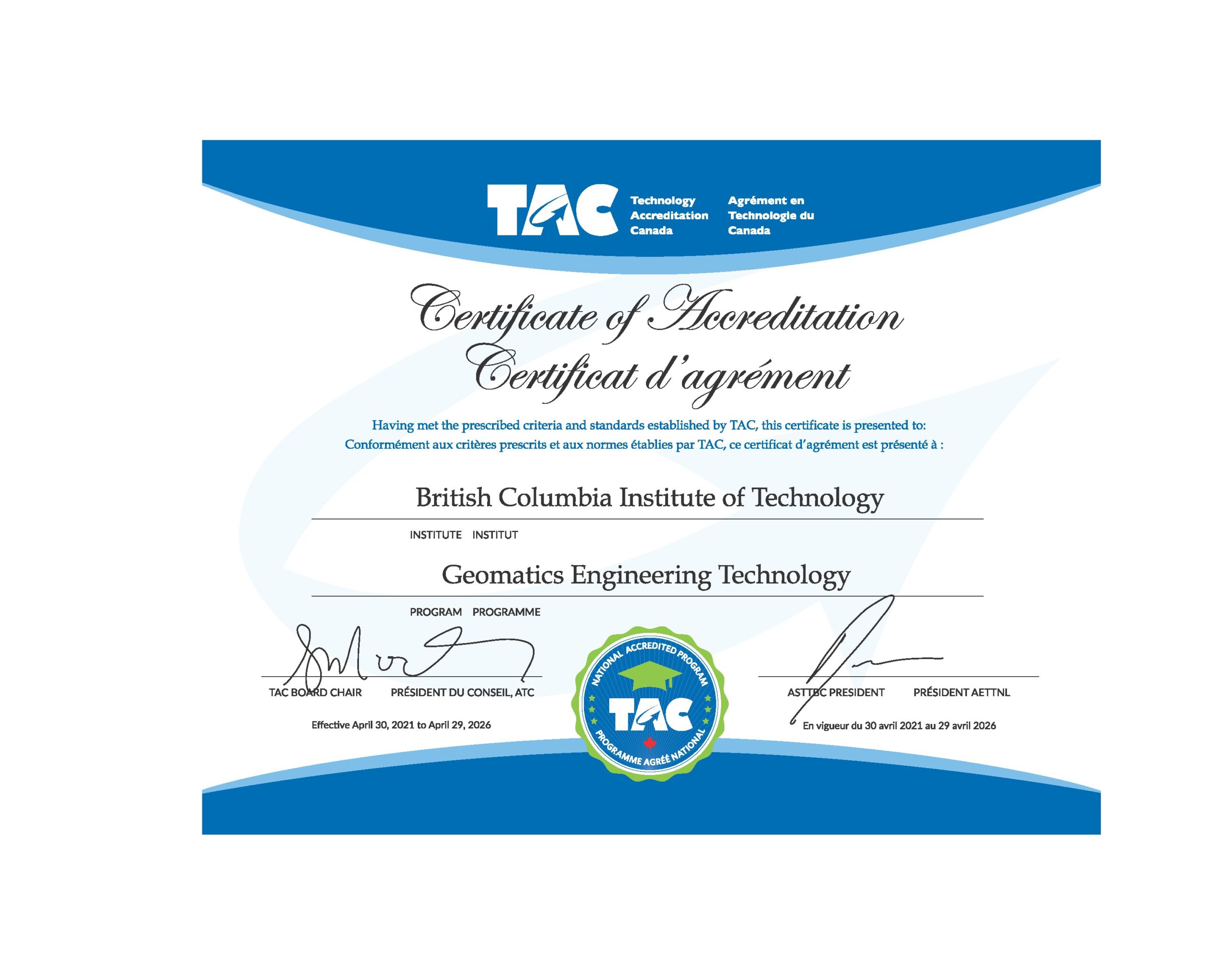
The BCIT Geomatics Engineering Technology Diploma is a two-year, full-time program designed to prepare graduates for positions in a high-demand career field. Taught by faculty with extensive industry expertise, the program culminates in the award of a nationally recognized credential, accredited by Technology Accreditation Canada (TAC Canada).
Program Goals
On completion of the Geomatics Engineering Technology Diploma, you will be proficient in:
- Manage Geospatial Data: Synthesize and manage the entire life cycle of geospatial information – from collecting and processing diverse data types to analyzing, translating, and presenting findings from field and remote sensing sources.
- Engineer Survey Solutions: Design and establish robust horizontal and vertical survey networks, conducting precise error analysis and adjustments using industry leading software.
- Leverage Existing Information: Skilfully research, analyze, and apply existing geomatics data from survey plans, reports, and various documents to inform new projects.
- Direct Field Operations: Confidently evaluate and select the optimal survey equipment and methods for any geomatics project, then interpret and analyze the captured data to produce accurate digital plans and reports.
- Execute Engineering Surveys: Precisely perform surveys essential for design, construction, and detailed layouts in civil engineering projects.
- Apply Geodetic Principles: Apply the principles of celestial coordinate systems, time systems, and Earth properties for advanced geodetic computations and surveys.
- Process Aerial Imagery: Expertly employ aerial photos and photogrammetry to create high-quality topographical maps and a diverse range of photogrammetric products.
- Communicate Effectively: Efficiently communicate complex survey project results to both colleagues and clients, while adeptly managing project records and inventories.
Academic Years 1 and 2
- The program is structured across two academic years, each comprising two terms (Levels 1 & 2 in Year 1; Levels 3 & 4 in Year 2).
- Levels 1 and 3 are 15 weeks (September to December). Levels 2 and 4 are 20 weeks (January to May), including a one-week Spring Break.
- Students typically undertake six courses per term, with Term 4 having seven courses. Field Surveying courses require additional lab hours.
- Classes are scheduled Monday through Friday, 8:30 AM to 5:30 PM, with Wednesdays concluding at 2:30 PM.
- Students with relevant industry experience or a related credential may be eligible for the Geomatics Flexible Learning Direct Entry program, allowing them to enter Academic Year 2 and earn their diploma upon successful completion of Level 4.
Core Competencies & Foundational Knowledge
Upon completion of the program, graduates will comprehend the fundamental importance of Geomatics to society and its intricate relationship with diverse disciplines, including:
- Land Surveying (Legal and Construction)
- Engineering & Architecture
- Earth & Ocean Science
- Construction
- Photogrammetry (measurement using aerial or terrestrial photographs)
- Remote Sensing (satellite images)
- Geodetic Surveying
- Geographic Information Systems (GIS)
- Oceanography & Space Exploration
Applied Measurement & Data Management
Students will acquire proficiency with a range of industry-standard equipment utilized for the measurement, storage, management, retrieval, and presentation of geographic-based information. This includes, but is not limited to:
- Total Stations
- Levels
- Gyro Theodolites
- GNSS (GPS) Satellite Positioning Systems
- Soft-copy Stereo Plotters
- Laser Scanning and LiDAR Systems
- Aerial Drones (RPAS)
- Electronic Data Collectors
- Fundamental tools such as compasses and maps
Advanced Principles & Practice
The curriculum will further elucidate the principles governing the Earth’s shape, its gravity field, and their direct impact on survey measurement and the comprehensive collection, analysis, and application of geospatial data. Throughout the program, a strong emphasis is placed on quality control and safety protocols to ensure professional practice.
Program length
Two years, full-time.
The program runs from September to May each year.
Accreditation
The Geomatics Engineering Technology diploma program is accredited by TAC (Technology Accreditation Canada) and ASTTBC (Applied Science Technologists and Technicians of British Columbia) as a technologist program. Full-time students may apply for student membership in ASTTBC. Graduates are eligible for graduate technologist membership and may apply for registration as an applied science technologist after completing a minimum of two years of relevant experience.
Program delivery
In person: This program is delivered on campus.
Program location
Burnaby Campus
3700 Willingdon Avenue
Burnaby, BC
Continue your education
Following completion of the two-year diploma program, students can apply to continue for a further two years towards BCIT's Bachelor of Science in Geomatics.
Graduates of the diploma program are granted course credits at the University of Calgary (Geomatics Engineering department), University of New Brunswick, and Oregon Institute of Technology, and also towards examinations set by the Canadian Board of Examiners for Professional Surveyors (CBEPS), leading to registration as a professional land surveyor. The diploma program is recognized by the Washington Land Surveyors as two years credit toward professional certification.
Graduating & Jobs
Job opportunities
Geomatics Engineering Technology graduates are in high demand. Job opportunities are mostly found with surveying and engineering firms as well as companies involved in oil and gas, mining, and other resource-based industries. Government mapping, planning, and engineering departments and a range of utility companies are also typical employers.
BCIT’s Geomatics diploma is accredited by TAC (Technology Accreditation Canada) and recognized internationally. Employment may be found throughout Canada and around the world.
Graduate employment outcomes
The BCIT student outcomes report presents summary findings from the annual survey of former students administered by BC Stats one to two years after graduation. These reports combine the last three years of available results for the 2023-2025 BCIT Outcomes Surveys of 2022-2024 graduates and for Degree 2021-2023 graduates. The reports are organized into three-page summaries containing information on graduates’ labour market experiences and opinions regarding their education. More detailed information can be accessed at the BC Student Outcomes website.
To view these results, you may need to have the Adobe Acrobat Reader installed in your Web browser.
Faculty, Advisors & Staff
Faculty
Mark Dailey, BCLS, P.Surv
Program Head
Tel: 604-432-8627
Email: mark_dailey@bcit.ca
James Cowan, AScT, BSc
Marketing & Media
Tel: 604-432-8992
Email: jcowan@bcit.ca
Sean Galway, BSc, MSc
Tel: 604-432-8283
Email: sgalway@bcit.ca
Ian Gatrell, DiplT
Tel: 604-431-4960
Email: ian_gatrell@bcit.ca
Christopher Griffith, BSc
Tel: 604-431-4943
Email: cgriffith9@bcit.ca
Scott Netherton, BCLS, CLS, P.Surv
Tel: 604-431-4993
Email: snetherton@bcit.ca
John Ogundare, PhD
Tel: 604-431-4944
Email: john_ogundare@bcit.ca
Klint Poonoosamy, DiplT, AScT, BTech
Tel: 604-451-7197
Email: klint_poonoosamy@bcit.ca
Mohammad Rajabi, PhD, EIT
Tel: 604-432-8706
Email: mrajabi@bcit.ca
Mohamed Abdel-Salam, P.Eng, CLS, ALS(Ret), BCLS
Tel: 604-456-8097
Email: mohamed_abdelsalam@bcit.ca
Evan Yao, AScT, BCE, MBA
Tel: 604-456-8164
Email: evan_yao@bcit.ca
Robert Scott, ALS (Ret.), P. Eng. (Ret.)
Tel: 604-412-7661
Email: robert_scott@bcit.ca
Cristopher Griffith
Coordinator – Part Time Studies
Tel: 604-431-4943
Email: cgriffith9@bcit.ca
Staff
Ron Tuck
Survey Stores Coordinator
Tel: 604-451-6704
Email: rtuck4@bcit.ca
Program Assistant
Tel: 604-451-7001
Email: geomatics@bcit.ca
Advisory committee
- Harinder Badial (Chair) – City of Surrey
- Warren Barnard – Watson & Barnard
- Joe Coelho – Matson, Peck & Topliss
- Rob Glass – City of Vancouver
- Mark LeBlanc – Canadian Hydrographic Service
- Jeff Liedtke – DWB Consulting
- Trevor Key – BC Ministry of Transportation & Infrastructure
- David Mostyn – Terra Remote Sensing
- Kevin Percy – Pro-Tech Surveys Ltd
- Steve Rombough – McElhanney Ltd
- Cristin Schlossberger – Land Title & Survey Authority of BC
- Leslie Sick – Association of BC Land Surveyors
Flexible Learning
Your Geomatics Career? Your Schedule. Your Pace.
Life’s busy, but your ambition doesn’t wait. BCIT Geomatics Flexible Learning puts you in command. Dive into new skills, upskill for career advantage, or simply advance your expertise seamlessly with our part-time and online Geomatics courses.
Learn Your Way. Advance Your Future
Discover cutting-edge Geomatics on your terms. Access industry-leading content and practical skills when and where it works for you:
- Evening Classes: Dynamic, in-person learning that complements your workday.
- Online Courses: Master complex Geomatics concepts from home or office, accessing materials 24/7.
- Modular Learning: Build expertise course by course, focusing on specific in-demand skills like CAD drafting, field surveying basics, remote sensing fundamentals, or GIS applications.
- Immediate Application: Apply Geomatics skills today in construction, civil engineering, and other key industries for instant career impact tomorrow.
Direct Entry Program: Accelerate Your Advancement
Have significant education or extensive industry experience in a related geospatial field? Our BCIT Geomatics program offers direct entry pathways that recognize your expertise. Qualified individuals can leverage their prior learning for advanced standing, rapidly accelerating their progress towards a BCIT Geomatics credential. For questions regarding eligibility, contact our Flex Learning Coordinator.
Your Direct Path to Professional Credibility
Crucial to your professional journey, every Geomatics course completed within our CBEPS aligned curriculum directly contributes to provincial professional licensure across Canada. BCIT Geomatics Flexible Learning courses are a pathway to earning a CBEPS Certificate of Completion, a vital step for becoming a licensed land surveyor across Canada.
Ready to make your move? Don’t just plan – build your future, one course at a time.
Explore our flexible Geomatics courses now. Sign up to secure your spot! Your next career
breakthrough starts here.
BCIT Geomatics Direct Entry Level 3 Bridging Courses offered in Spring term only:
GEOM 2110 Pre-Entry Field Surveying (delivered in-person)
GEOM 2120 Pre-entry Survey Computations (delivered online)
GEOM 2130 Pre-Entry CAD and Geospatial Software Applications (delivered online)
BCIT Geomatics department offers the following courses on campus:
GEOM 1000 Introduction to Surveying & Geomatics (Fall term only)
SURV 1101 Survey Instrument Operations: Levels (Winter term only)
SURV 1104 Basic Surveying with Total Stations (Winter and Fall terms)
SURV 1111 Basic Surveying with GNSS (Fall term only)
SURV 2205 Civil 3D: Introduction (Winter, Spring and Fall terms)
SURV 5108 Fundamentals of Surveying (Winter, Spring and Fall terms)
Please note – these course offerings are subject to change.
The list of online Flexible Learning courses below have been granted exemptions by CBEPS. Students may receive approval to register for these online courses with completion of two-year Geomatics diploma, and meeting all other prerequisites. To receive approval, students must submit their official academic transcript(s) and BCIT Student ID to geomatics@bcit.ca. You can create your BCIT Student ID at https://secure.bcit.ca/sis/reg/.
GEOM 1021 Surveying Computations 1
GEOM 3051 Introduction to Geodesy
GEOM 3071 Introduction to Photogrammetry
GEOM 4016 Remote Sensing & GIS
GEOM 6106 GIS Applications
GEOM 6121 Physical Geodesy
GEOM 6165 Advanced Photogrammetry
GEOM 7121 Satellite Geodesy
GEOM 7150 Advanced Topics in Precision Survey
and
SURV 1125 Unmanned Aircraft Systems Applications for Geomatics (Spring and Fall terms) – not for CBEPS exemption
Please note – these course offerings are subject to change.
The courses that are not offered through Flexible Learning are available to full-time students in the full-time program only. In order to enroll in day school courses (on campus only), you need to apply and be accepted to the program. Once you are accepted you can decide which courses you want to be enrolled in and can drop all other courses. Please note that there is no exception to this as it is a BCIT policy.
Contact:
- Program Assistant (604-451-7001)
- Flexible Learning Coordinator (604-431-4943)
Industry training
BCIT Geomatics Engineering Flexible Learning is available to consult with your company to develop specific courses to meet your needs in a variety of Geomatics and Land Information related topics. We also offer employee assessment in the Geomatics field. Please contact Christopher Griffith for details.
CBEPS
The Canadian Board of Examiners for Professional Surveyors (CBEPS) establishes, assesses, and certifies the academic qualifications of individuals who apply to become land surveyors and/or geomatics professionals in Canada.
Exemptions to writing some or all CBEPS examinations are granted to candidates who have graduated from an accredited University degree program or from a Technical Institute diploma program that has been granted equivalencies. A list of universities and technical institutes with relevant exemptions is available on the CBEPS website.
The BCIT Geomatics department offers the following online Flexible Learning (formerly Part-time Studies) courses which have been granted exemptions by CBEPS. Students may receive approval to register for these online courses with completion of two-year Geomatics diploma, and meeting all other prerequisites. To receive approval, students must submit their official academic transcript(s) and BCIT Student ID to geomatics@bcit.ca. You can create your BCIT Student ID at https://secure.bcit.ca/sis/reg/.
GEOM 1021 Surveying Computations 1
GEOM 3051 Introduction to Geodesy
GEOM 3071 Introduction to Photogrammetry
GEOM 4016 Remote Sensing & GIS
GEOM 6106 GIS Applications
GEOM 6121 Physical Geodesy
GEOM 6165 Advanced Photogrammetry
GEOM 7121 Satellite Geodesy
GEOM 7150 Advanced Topics in Precision Survey
Please note – these course offerings are subject to change.
The courses that are not offered through Flexible Learning are available to full-time students in the full-time program only. To enroll in day school courses, online or on campus, you need to apply and be accepted to the program. Once you are accepted you can decide which courses you want to be enrolled in and can drop all other courses. Please note that there is no exception to this as it is a BCIT policy.
Contact:
- Program Assistant (604-451-7001)
- Flexible Learning Coordinator (604-431-4943)
In addition to these are three Business Practices and Profession courses required for the C11 exemption offered through the BCIT School of Business:
BLAW 3100 – Business Law
BUSA 7250 – Management Skills & Applications
ECON 1150 – Economic Issues
Contact Us
Please contact Program Advising if you have questions about:
- Application process
- Entrance requirements
- Applying for transfer credit and advanced placement
- Program costs
- Job placement and graduate outcomes
Tel: 604-434-1610
Email: program_advising@bcit.ca
Program Assistant
Tel: 604-451-7001
Email: geomatics@bcit.ca
Questions or comments?
Subscribe
Sign up to receive updates, invitations to events, and information about BCIT and your program.
We promise not to spam you, we won’t share your personal information, and you can unsubscribe at any time.
Programs and courses are subject to change without notice.