Geomatics: Map Your Future Shape Your World
Step into a field where innovation meets impact. Geomatics is the dynamic science of measuring, analyzing, and presenting geospatial data – the essential intelligence underpinning smart city development, environmental protection, autonomous vehicle navigation, and cutting-edge civil engineering and construction projects. As technology rapidly advances, Geomatics professionals drive sustainable solutions, making a tangible difference. Are you analytical, tech-passionate, and ready to turn data into discovery? The BCIT Geomatics program is your launchpad to a high-demand career.
 Unlock Limitless Possibilities with BCIT Geomatics
At BCIT, master real-world applications, not just theory. Our Geomatics Engineering Technology program is meticulously designed for high demand.
Choose Your Path to Professional Excellence
- Geomatics Diploma (2 Years): Gain a robust, TAC Canada accredited foundation with highly sought-after skills in field surveying, precision CAD drafting, advanced remote sensing (inc. laser scanning), hydrography, and more.
- Bachelor of Science in Geomatics: Add two years to deepen knowledge, specialize, and unlock advanced leadership opportunities, including pathways to becoming a professional land surveyor (e.g., BC Land Surveyor).
Why BCIT Geomatics? Your Advantage Starts Here
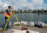
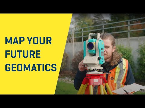
- Hands-On Learning: Work with cutting-edge GPS, advanced surveying equipment, precise photogrammetry, and powerful GIS software from day one. Learn by doing, just like the industry.
- Learn from Industry Leaders: Our faculty are Geomatics industry experts. Their invaluable insights and up-to-date expertise directly guide your industry-driven curriculum, ensuring your education delivers cutting-edge skills precisely aligned with what employers demand, making you job-ready and highly valuable from day one.
- Diverse Career Paths: Whether you thrive outdoors or in a high-tech office, Geomatics offers rewarding careers across Canada and beyond. Develop advanced mapping systems, contribute to environmental protection, shape the built environment through civil engineering and construction, or explore drone technology applications.
- Flexible Learning: Juggling commitments? Our Geomatics program offers full-time, part-time, and online options designed to fit your life, and crucially, our curriculum aligns with the new CBEPS syllabus. Courses directly contribute to professional licensure requirements. Whether pursuing a full credential or individual courses, your studies provide a clear gateway to a CBEPS Certificate of Completion, essential for becoming a professional land surveyor across Canada. Students interested in CBEPS courses should contact our Flex Learning Coordinator to confirm academic requirements.
- Direct Entry Advantage: Already have a strong background? Our Geomatics program recognizes your prior education or experience, offering pathways to advanced standing that accelerate your progress towards a BCIT Geomatics credential. Contact our Flex Learning Coordinator to learn more.
- Experience BCIT Geomatics Firsthand: Get an immersive look into our program through the BCIT Spend a Day program (and see our field labs in action!), or have our expert faculty visit your school (in-person or virtually) to bring the world of Geomatics directly to you.
Don’t Just Observe the Future – Build it
Explore BCIT Geomatics programs today. Ready to transform your career and carve out your place in the spatial world? Take the next definitive step. Connect with a program advisor to discuss your future, attend an upcoming online info session, or download the comprehensive program guide for all the details. Don’t wait – your high-demand Geomatics career starts now.
Apply today!
Jonathan Gallant, BCIT Graduate“I entered the Advanced Placement program and in just 1 year I graduated with a two year diploma in Geomatics Engineering. I had a job offer before I finished school and was able to start work immediately after graduating! BCIT gave me the skills and the knowledge to feel confident entering the surveying industry. The teachers are excellent and go to great lengths to teach a daunting amount of material in as efficient and manageable a way as possible for the students.”
Neil Bennett BCLS CLS President Bennett Land Surveying“Bennett Land Surveying has employed many BCIT graduates over the years, we have found them to be well qualified and familiar with the modern technology used throughout the surveying industry. Three of the partners at Bennett are BCIT graduates and a large percentage of the practicing land surveyors in BC are grads of BCIT. The Geomatics programs at BCIT are an excellent stepping stone towards an exciting future career in land surveying.”