Master of Science (M.Sc.) in Applied Computing students are finishing up their first year of courses, preparing to go into industry internships and projects, or to pursue a thesis, in their second year.
As part of their second term of coursework, students complete COMP 9130: Applied Artificial Intelligence (AI). The course focuses on concepts and issues in AI algorithms and leads to a final applied project of optimizing AI outputs, such as accuracy and speed, while solving a real-world issue in industry or society.
AI models: Accuracy is determined by training data
When building an AI model, the quality, quantity, and diversity of information available is what generally determines its accuracy and usefulness. After studying broader AI topics and methodologies, students practice designing, developing, and improving AI algorithms by drawing on different datasets. Teams presented their final projects earlier this month.
Research questions ranged from teaching AI systems to recognize locations inside buildings with no GPS available to dual-use applications of computer vision.
Learn more about the Master of Science in Applied Computing
Can AI overcome camouflage in visual detection?
Camouflage, be it an animal’s natural colouring or human-engineered clothing and cover, is developed specifically to defeat visual detection. Whether designed for desert, forest, or snowscape, this disguise blends into landscape. Team members Binger Yu, Yansong Jia, and Sepehr Mansouri worked to help computer vision overcome this concealment.
“We wanted to solve a problem that sits at the intersection of data scarcity and computer vision,” explains Binger. “There are few military camouflage images available, so we had to get creative with how we trained our models.”
This area of work is “dual-purpose,” meaning it has potential for both civilian and military uses. It can be applied to mapping and tracking animal populations or detecting human activity, whether it be civilian search-and-rescue or an armed forces application.
Promising Results
“We used three experimental configurations,” explains Sepehr. “Two of these performed well in identifying camouflage across various terrains, differentiating animals versus military personnel and finding them in the landscape.”
“What surprised us was how well features learned from animal camouflage transferred to detecting military personnel,” says Yansong. “The two domains are visually very different, but the underlying challenge — finding something that is trying not to be found — turns out to be something AI can learn across both.”
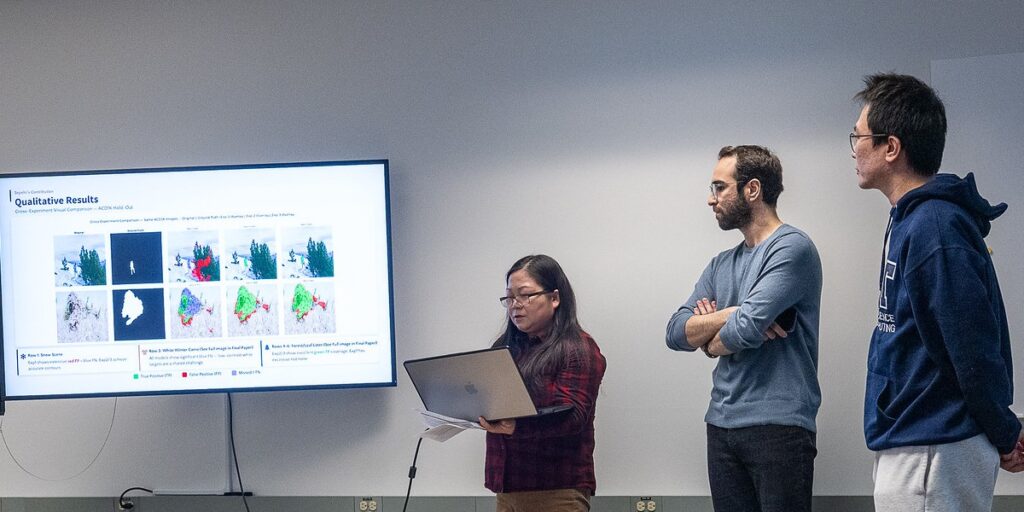
The team was pleased with the results and the prospects for future application.
“This kind of work shows how AI can be applied to real-world problems where the stakes are high and the data is limited,” says Sepehr. “The techniques we used here – transfer learning and careful data engineering – are broadly applicable beyond camouflage detection.”
Weather barriers in autonomous vehicle systems development
Object detection in adverse weather is a significant barrier in intelligent transportation technology, such as Autonomous Vehicle (AV) development. Brendan Zapf, Michael Persson, and Timothy Tan took on this challenge by training AI models on weather images.
“We wanted to evaluate the performance and robustness of the newest models in adverse weather conditions,” says Timothy. “It’s essential for AVs to be able to detect objects, including vehicles and pedestrians, whether in fog, rain, or snow.
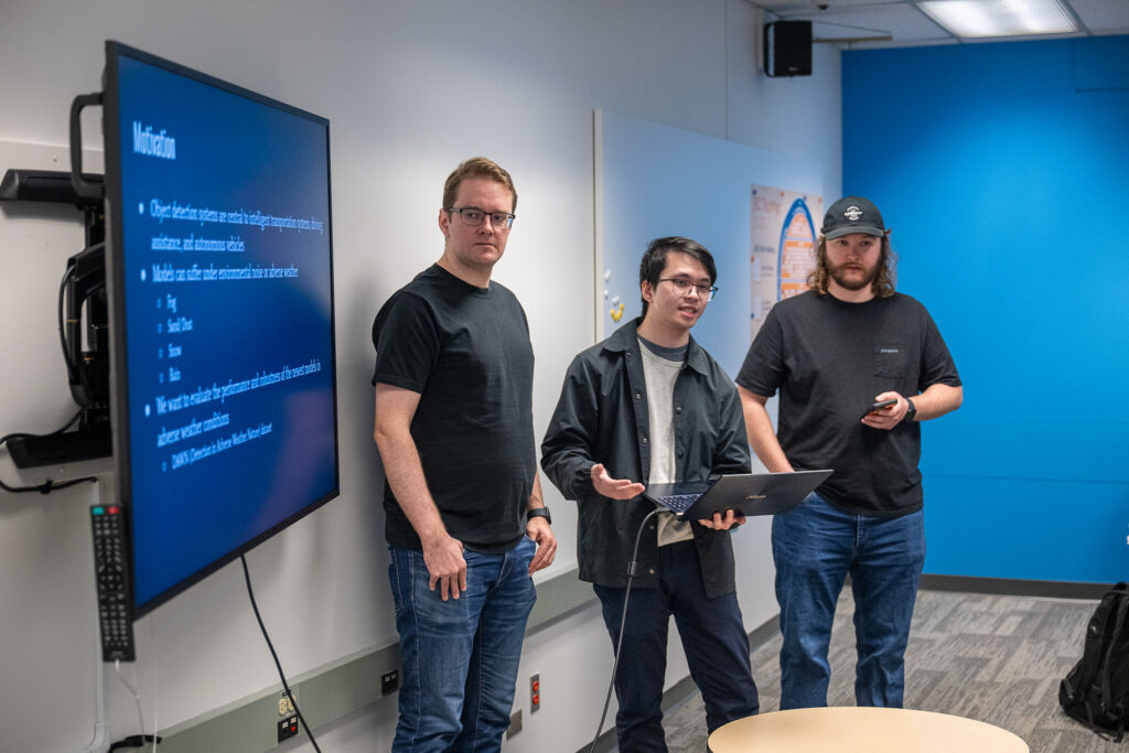
The team found the models performed differently across the varied conditions, with one model better in fog, and another better in snow. “We were impressed that the latest models performed fairly well, even with a more limited dataset of only 1000 images” says Michael.
“This work needs to be extended to nighttime and compound weather scenarios,” adds Brendan, pointing out that the dataset was comprised only of images taken during the day in single weather conditions.
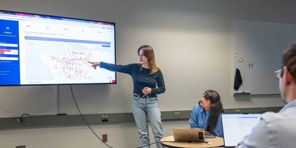
Predicting preventive road repair (or everyone hates potholes)
Savina Cai, Ledja Halltari, and Alex Liu used Vancouver Open Data to assess pavement condition, in an effort to improve preventive municipal road repair. More severe damage leads to more complex and costly repair, beyond the obvious transportation inconvenience and danger. Thus effective prediction and proactive amelioration has many benefits across infrastructure applications.
The team considered 23 datasets, including the Pavement Condition Index, service requests, and weather data. They combined four base models – a technique known as fold stacking – to derive more accurate predictive results in categorizing risk of needed repair from low to high.
“Working with real Vancouver Open Data showed us how machine learning can directly support city infrastructure planning,” explained the team.
“By predicting which roads need repair before conditions worsen, models like ours could help municipalities prioritize limited maintenance budgets and keep communities safer.”
Preventive road repair is just one application. “The same approach — combining multiple public data sources with ensemble methods — could be applied to other infrastructure challenges like water mains, bridges, or transit systems,” says the team. “We’re excited about where this line of research could go.”
Moving into industry
“I was impressed with the projects,” reports Dr. Aaron Hunter, Associate Dean, who came to watch the presentations.
“I look forward to seeing what these students do in their second year, whether it be via the industry internship and project path, or a thesis.”
Top photo: Ledja Halltari presents as Savina Cai looks on (photos by Scott McAlpine)
Keep up with the latest from BCIT Computing through our Tech It Out quarterly newsletter.